The summer of the Jirisan Ridge hike
If you are one of many outdoor-loving Koreans, the Jirisan ridge hike and seeing the sunrise from the highest peak Cheonwangbong (1915m) is probably on your wish list of things to do. It was on mine. Jirisan is a spiritually important mountain for our people, along with Seoraksan in the east and Hallasan in Jeju island. You might have noticed now, ’san’ means mountain in Korean, so you can say Jiri Mountain as well. Jirisan is known for holding maternal energy, like getting a big hug from Mother Nature. That’s because our ancestors believed that the smooth peaks and bow-shaped ridges represent the feminine energy of nature. I hiked there many years ago during my Templestay experience in Hwaumsa, but the ridge hike is something of a different genre.

Jirisan turns you into a wise man and the Sky God is strict
It’s named Jirisan (Jiri Mountain, 智異山) because it was believed to have the power to give common people wisdom. Jirisan National Park was declared the nation’s first national park and it is the biggest. The national park lies in three provinces, Jeollabukdo, Jeollanamdo, and Gyeongsangnamdo. Sunrise from the tallest peak Cheonwangbong (1915 m) is the most beautiful scene in Jirisan. However, it’s notorious for often being in the fog. There was an old saying that the Sky God (or the guardian of the land) only allows you to see the sunrise if three generations of your family did a lot of good deeds.
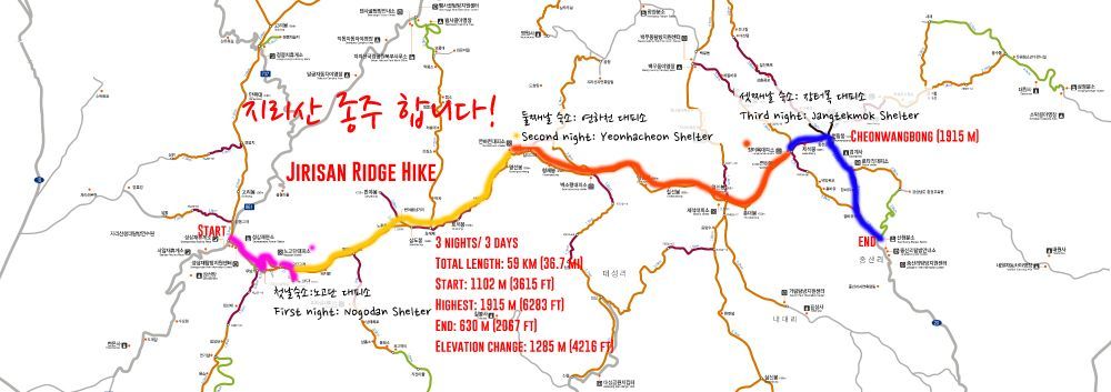
Jirisan is one of the most beloved mountains in Korea. There are many hiking trails that are well-known for their exquisite landscape. The classic ridge hike is the one that walks on the 25.5km main ridge from Nogodan Peak to Cheonwangbong Peak, which is the second tallest peak in South Korea after Hallasan (1950 m) on Jeju Island. The starting and ending points can vary, though the traditional route starts from Hwaumsa Temple and ends in Daewonsa Temple, which stretches about 59km. The elevation difference between lowest to highest is 1285 m (4216 ft). There are 16 peaks that are higher than 1500 m (4921 ft) on the main ridge. This is considered one of the most important hiking courses for Koreans to complete.
I’m happy to report that I’ve done it, I’ve seen it, and I’ve lived it.
Planning for Jirisan Ridge Hike
For four days and three nights, Stephen and I hiked the main ridge of Jirisan. It was an amazingly beautiful hike, but most of all, it was a spiritually important experience for me as a Korean. We Koreans thrive on the spiritual connection with our homeland. But certainly, the Jirisan ridge hike is worth hiking no matter where you’re from. You’ll see the ocean of clouds from mountain peaks, Jirisan’s unique wildflowers, waterfalls as old as the earth, and much more.
For your successful planning, here is the complete guide to the Jirisan Ridge hike.
Jirisan Ridge Hike Full itinerary
Date: July 18 – 21 [please note that preparation for each season will be different]
- July 18 Monday (5.2km hike)
- Seoul – Gurye (3.5 hours by bus)
- Reach the trailhead at Sungsamjae (성삼재 휴게소) and hike to Nogodan Peak (1507m/ 4944ft)
- Spend the first night at Nogodan Shelter
- July 19 Tuesday (13.6km/8.45mi hike)
- Hike to Yeonhacheon Shelter via Banyabong Peak (1732m/5682.4ft)
- Spend the second night at Yeonhacheon Shelter (1480m/4655.6ft)
- July 20 Wednesday (13.3km/8.26mi hike)
- Hike to Jangteomok Shelter
- Spend the night at Jangteomok Shelter (1653m/5423ft)
- July 21 Thursday (7.1km/4.41mi hike)
- See the sunrise at the highest peak Cheonwangbong Peak (1915m/6283ft)*
- *Let’s see if Kim family did a lot of good deeds.
- Hike down to Baekmudong

Jirisan is well-managed with many shelters, so it makes it easier to plan the hike from shelter to shelter. Please see below how to use the national park’s shelter reservation system.
As I said earlier, starting from Hwaumsa Temple and ending at Daewonsa Temple has been known as the classic ridge hike. But since the park built a road up to Sungsamjae, which is the highest point cars can go in Korea, the Sumgsamjae-Nogodan path became more popular as a starting point. There are several options for descending, and we chose the Baekmudong course. If you are heading back to Seoul or the northern part of Korea, Baekmudong has more options. Jungsanri course is also popular, and there is transportation connecting from Jinju city. If you want to continue the classic ridge hike, you can hike down to Daewonsa.
Packing for Jirisan ridge hike
As you can imagine, it gets cool in the mountains even in summer, especially if you’re on the top of the ridge. Pack a couple long-sleeved shirts and a jacket to layer. Shelters are heated, so no need to worry about being cold at night. All the shelters have blankets to rent but I recommend bringing a sleeping bag if you have extra room.

For food, calculate exactly what you want to eat for each meal and how much gas you’ll need to cook. Find a way to reduce trash, since you will have to carry everything out. Each shelter has running water, and a small store that sells camping gas, instant ramen noodles, cooked rice, and some snacks.
Other items I packed: two walking poles, headlamp, STERI Pen, sunscreen, body balm, kuksa, mosquito repellant, eye patch and earbuds, wet wipes, toilet paper, one-day contact lenses, water bottles, sleeping bag, and pocket knife.
Our bags were 12kg and 14kg at the start.

Jirisan National Park How to Do It Right

Shelters
Korea’s national parks have shelters that you can use to rest and stay overnight. When I say well-equipped, I mean it. The shelters have running water, sleeping compartments, blankets and sleeping pads for rent, heaters, a small store (for food and camping equipment), power outlets, and wireless internet. The facilities have been upgraded over the past decade. Welcome to Korea’s national parks!
If you are planning a multiple-day hike, you must reserve a shelter in advance. National parks don’t allow anyone to hike at night or cook and sleep anywhere other than shelters. The only way to make a reservation is through the national park’s website. If you’re a foreigner, they allow you to pay at the shelter as long as you make a reservation beforehand. As a Korean member, you’ll have to pre-pay to complete your reservation.
For the ridge hike, you’d want to stay at Jangteomok Shelter for your last night, because it’s located below the Cheonwangbong Peak. When you make a reservation, book Jangteomok first and plan backward. For example, if you are doing the same root as me (Nogodan Shelter-Yeonhacheon Shelter-Jangtemok Shelter), reserve the last night’s stay at Jangteomok first and book the rest. It’s often fully booked especially in summer and autumn.
- National park website: http://english.knps.or.kr/
- Shelter reservation system: https://reservation.knps.or.kr/foreigner/main.action
Map for Jirisan ridge hike
The national park office in Sungsamjae and other offices have a map of the trails in both English and Korean. Make sure you carry a map so you know your way.
I’ll describe more details about each day in the individual posts.
Download the complete map of Jirisan National Park
No chemicals
Since we’re using spring water from the mountain, the national park regulates the use of soap and toothpaste. The same springs are the water source for the villages downstream, so we have an obligation to protect the purity of the spring. If you need to use soap or toothpaste, bring something with all-natural ingredients, and don’t deposit your waste directly in the stream.
No smoking
All national parks are strictly non-smoking areas. No need to mention why.
Follow the trail
Jirisan is an Asiatic black bear preservation area. The number was once dangerously low but due to the constant preservation effort, now there are quite a number of them living in Jirisan. There is a chance to run into the bears or wild boars in the woods. Walk only along the designated trails. Wild animals usually don’t attack people without being provoked. Oh, and you have to pay a fine if you go trailblazing.
No trash, please
There are no trash cans within the national park. Make sure to pack everything out!
Look out for the difficulty levels
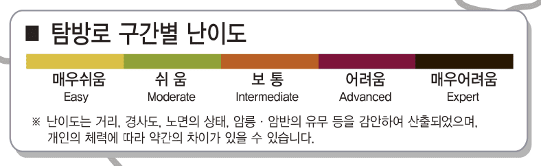

The national park’s hiking paths are labeled with five different levels. Each map is clearly labeled.
Easy – Moderate – Intermediate – Advanced – Expert
Now, are you ready for the Jirisan ridge hike?
The Complete Guide to the Jirisan Ridge Hike
Jirisan Ridge Hike Full Series
![The Complete Guide to the Jirisan Ridge Hike [4] Cheonwangbong Peak Sunrise Extravagant](https://runawayjuno.com/wp-content/uploads/2017/06/2016.07_Jirisan-4659.jpg)
![The Complete Guide to the Jirisan Ridge Hike [3] Yeonhacheon Shelter – Jangteomok Shelter](https://runawayjuno.com/wp-content/uploads/2016/08/Jirisan_3.png)
![The Complete Guide to the Jirisan Ridge Hike [2] Nogodan – Yeonhacheon Shelter](https://runawayjuno.com/wp-content/uploads/2016/08/Jirisan_2.png)
![The Complete Guide to the Jirisan Ridge Hike [1] Sungsamjae – Nogodan Shelter](https://runawayjuno.com/wp-content/uploads/2016/08/Jirisan_1.png)
[0] Preparation and Things to Remember
[1] Day 1: Sungsamjae – Nogodan Shelter
[2] Day 2: Nogodan – Yeonhacheon Shelter
[3] Day 3: Yeonhacheon Shelter – Jangteomok Shelter
[4] Day 4: D-Day Cheonwangbong Peak Sunrise Extravagant
