Rise and shine!
We’re heading to Yeonhacheon Shelter today.
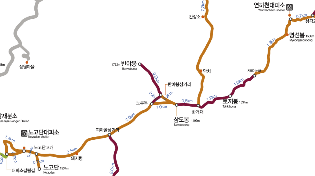
Today’s itinerary: Nogodan Shelter – Norumok (Banyabong Peak) – Samdobong Peak – Ttokibong Peak – Myungsunbong Peak – Yeonhacheon Shelter [10.3km]
It’s going to be a long day.
I slept about 9 hours without an alarm. Not well, but it was a long sleep. Along with other hikers, we prepare to leave for our first full-day hiking. The menu this morning is the heartiest breakfast of all: oatmeal and apple. Seems like we are the last ones leaving Nogodan Shelter at 8am. If you are looking into hiking longer than 10km in one day, the hiking path opens after 3am.
The weather this morning cannot be better. I was a bit worried because we were still in the rainy season in Summer. To Nogodan Pass, which is the point where you can go to Nogodan Peak, takes just about 10 minutes uphill from the shelter. The view of the ocean of clouds in Nogodan is one of the best views of Jirisan.

Now the real ridge hike begins.
We saw some nice views along the way. Keep in mind, your pace will be slower than average because of the heavy bag and all the captivating views. Hiking is not about reaching somewhere fast; it’s about the journey. We came all this way to be in nature, so it’s important to schedule the appropriate amount of walking each day to leave time to stop and smell the flowers, literally.

Fresh water springs, flowers, and ocean of clouds
One of many reasons why Jirisan has been beloved by people is because there are many sources of water. It’s a huge benefit to hikers that they don’t have to carry a full-days worth of water. You’ll reach Imgulryung spring after Banyabong Peak. But there are no more springs between here and Yeonhacheon Shelter, where we’re staying tonight, so fill the bottles up!
Every season, Jirisan presents different but equally amazing views. This summer, a lot of wildflowers are still in bloom. Some are unique to this environment.


Peaks, peaks, and peaks
Samdobong Peak (1499m) is the point where three provinces meet (Jeollanamdo, Gyeongsangnamdo, Jeollabukdo). Each side of this pointy monument on the peak shows where we’re standing. It’s about lunch time but the next point of interest, Hwagaejae, is a better break point, which is about 1km away from here. Hwagaejae used to be a trading place between producers from the coast and mountains. It’s more familiar to Koreans because of a famous folk song about this place. In a clear day, the view from this spot is just stunning, so I’ve heard. Unfortunately, the afternoon clouds have already taken over.


From here to Yeonhacheon Shelter, the trail is quite difficult. It’s marked as advanced level. There are a series of uphills and downhills, but mostly the path is well-equipped with wooden staircases and stacked rocks. But still, the weight of the bag isn’t something we can ignore. Concentrate, look exactly where you can step, and take your time. It’s no race!
We climb over Ttokibong Peak (1534m) and Myungsunbong Peak (1586m) on the way to our shelter. There has been a lot of elevation change today. At about 3:30pm, we reach Yeonhacheon Shelter in the clouds. By the map, we walked 10.3km but my GPS calculated as 13.1km for 7.5 hours. Not a bad rate. Good job, us!
First day record: 13.1km for 7.5 hours

After we check in, the area around the shelter is still in the clouds. Fog moves in and out while we prepare our early dinner. After walking for 7.5 hours, we deserve two dinners, don’t we? But right after the hike is the most crucial time to preserve our body’s heat. Sweat takes away the heat really fast, so do a light stretch and put on a jacket even though you feel sweaty and disgusting.

Yeonhacheon Shelter is no Nogodan Shelter, but I would still say it’s glamping
Yeonhacheon Shelter is different than Nogodan Shelter. Facilities are a lot simpler, electricity is from the solar panels, and running water is from the stream in front of the shelter. Yeonhacheon Shelter is actually named after this stream of the same name. The sleeping area is similar to Nogodan but there are not many power outlets. There is an extension outside of the room door but you have to act fast to get a spot to charge your electronics (especially if there’s a school group). And of course, there is wireless internet. But since you’re in the mountains, try separating yourself from electronics and experience your surrounding nature in 3D. Sleeping pads here aren’t as thick as yesterday’s, so a blanket will work better than a sleeping pad.
No sunset today. We turned in early for an even longer day of walking tomorrow after our a second dinner.
Today’s expense
Blanket 2000won
Shelter 8000won

The Complete Guide to the Jirisan Ridge Hike: full series
[0] Preparation and Things to Remember
[1] Day 1: Sungsamjae – Nogodan Shelter
[2] Day 2: Nogodan – Yeonhacheon Shelter
[3] Day 3: Yeonhacheon Shelter – Jangteomok Shelter
[4] Day 4: D-Day Cheonwangbong Peak Sunrise Extravagant
